
Documentation › Charts
Maps and ISO codes
Draw maps of Uganda's districts, other countries' regions and the world in Embiro BI, with the ISO codes each map needs and where to look them up.
Embiro BI has three kinds of map. The first two colour areas, which needs a column holding each area's ISO code. This page explains which code each map expects, lists every Uganda district's code, and points to the official sources for other countries.
| Map | Shows | Your data needs |
|---|---|---|
| Country Map | One country's regions or districts, coloured by a metric | An ISO 3166-2 code per row, such as UG-102 |
| World Map | Countries of the world, coloured or with bubbles | A country code (ISO 3166-1) or the country's name |
| Point Cluster Map and the deck.gl maps | Points at exact locations | Latitude and longitude columns |
ISO codes in a nutshell
- ISO 3166-1
- The international standard for country codes. Uganda is
UG(alpha-2),UGA(alpha-3) and800(numeric). Kenya isKE/KEN, TanzaniaTZ/TZA, RwandaRW/RWA. - ISO 3166-2
- Codes for each country's subdivisions (regions, provinces, districts). They start with the country's alpha-2 code:
UG-102is Kampala,KE-30is Nairobi,TZ-02is Dar es Salaam.
Official and reliable sources to look codes up:
- ISO Online Browsing Platform (the official ISO 3166 database: search a country, then open Subdivisions)
- ISO 3166-1 country codes (ISO's overview of the standard)
- Wikipedia: ISO 3166-2:UG (Uganda's subdivision codes, with history of changes)
- Wikipedia: ISO 3166-1 alpha-2 and alpha-3 (all country codes in one table)
- UN M49 country and area codes (numeric codes and regional groupings used in UN statistics)
- Uganda Bureau of Statistics (official district names and population figures to join to your data)
Country Map: Uganda by district
- Add the codes to your data. Usually your table has a district name, so join it to the code list below. The quickest way:
- download uganda-district-iso-codes.csv and upload it as a table, say
uganda_districts, or paste it into a Google Sheet; - join it in a virtual dataset (see the SQL below), or add the code as a column in your own system.
- download uganda-district-iso-codes.csv and upload it as a table, say
- Create a chart on that dataset and choose Country Map.
- Set:
- Country:
uganda; - ISO 3166-2 Codes: your code column, such as
district_iso; - Metric: what colours each district, such as
SUM(revenue_ugx); - Linear Color Scheme and Number format to taste.
- Country:
- Click Update chart. Hover over a district to see its name and value.
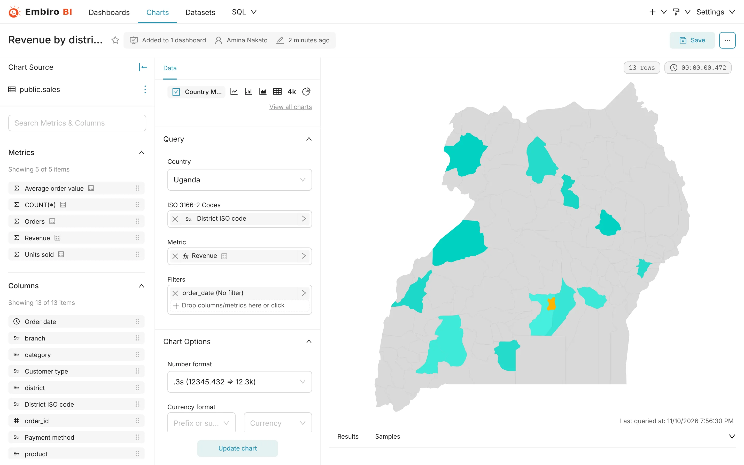
A virtual dataset joining sales to codes by district name (PostgreSQL):
SELECT s.*, d.district_iso, d.region
FROM sales s
LEFT JOIN uganda_districts d
  ON lower(trim(s.district)) = lower(d.district)
Spellings in the list follow the map, which sometimes differs from today's official spelling: Kibaale is listed as Kibale (UG-407). Rows whose district doesn't match a name in the list get no code and don't appear on the map. Check them with:
SELECT DISTINCT s.district
FROM sales s
LEFT JOIN uganda_districts d ON lower(trim(s.district)) = lower(d.district)
WHERE d.district_iso IS NULL;
Uganda's newer districts
The Uganda map in Embiro BI has the 111 districts of the 2010 boundaries, the ones that have ISO codes. Districts created later, such as Kagadi (from Kibaale), Omoro (from Gulu) or Rubanda (from Kabale), have no ISO code of their own. Map their rows to the district they were created from, in a small lookup table or a CASE expression, so their numbers still appear on the map:
sql
CASE lower(district)
  WHEN 'kagadi'   THEN 'UG-407' -- Kibaale
  WHEN 'kakumiro' THEN 'UG-407' -- Kibaale
  WHEN 'omoro'   THEN 'UG-304'  -- Gulu
  WHEN 'rubanda' THEN 'UG-404'  -- Kabale
  ELSE district_iso
END
Cities such as Mbarara City or Gulu City are within their district's area on the map: use the district's code.
Other countries
Country also offers Kenya, Tanzania, Rwanda, Burundi, the Democratic Republic of the Congo, Ethiopia, Somalia, Zambia, Malawi, Nigeria, Ghana, South Africa and about 190 other countries. Each expects that country's ISO 3166-2 codes: Kenya's 47 counties are KE-01 (Baringo) to KE-47 (West Pokot), Tanzania's regions TZ-01 to TZ-30. Look them up on the ISO Online Browsing Platform or Wikipedia's ISO 3166-2:KE and ISO 3166-2:TZ pages.
World Map
- Choose World Map.
- Set Country Column to the column holding the country, and Country Field Type to what that column contains:
- Full name, such as
Uganda(English names, spelled as in the ISO list); - code ISO 3166-1 alpha-2 (cca2), such as
UG(the most reliable choice); - code ISO 3166-1 alpha-3 (cca3), such as
UGA; - code International Olympic Committee (cioc), such as
UGA.
- Full name, such as
- Choose a Metric to colour countries. Optionally switch on Show Bubbles and choose a Bubble Size metric.
Names are easy to get wrong (Tanzania versus United Republic of Tanzania, DR Congo versus Democratic Republic of the Congo), so prefer two-letter codes.
Maps of points
To plot customers, branches or sales at their exact location, your dataset needs latitude and longitude columns in decimal degrees, such as 0.3476 and 32.5825 for Kampala. Use Point Cluster Map for many points grouped into clusters, or deck.gl Scatterplot and deck.gl Heatmap for density.
Getting coordinates: Google Maps shows them when you right-click a place, and most mobile data-collection tools (KoboToolbox, ODK, Jotform's location field) record them with each submission.
Uganda district ISO codes
The full list, matching the Uganda map. Region digits: 1 Central, 2 Eastern, 3 Northern, 4 Western. Download it as CSV.
Show all 111 districts
| ISO code | District | Region |
|---|---|---|
UG-101 |
Kalangala | Central |
UG-102 |
Kampala | Central |
UG-103 |
Kiboga | Central |
UG-104 |
Luweero | Central |
UG-105 |
Masaka | Central |
UG-106 |
Mpigi | Central |
UG-107 |
Mubende | Central |
UG-108 |
Mukono | Central |
UG-109 |
Nakasongola | Central |
UG-110 |
Rakai | Central |
UG-111 |
Sembabule | Central |
UG-112 |
Kayunga | Central |
UG-113 |
Wakiso | Central |
UG-114 |
Mityana | Central |
UG-115 |
Nakaseke | Central |
UG-116 |
Lyantonde | Central |
UG-117 |
Buikwe | Central |
UG-118 |
Bukomansimbi | Central |
UG-119 |
Butambala | Central |
UG-120 |
Buvuma | Central |
UG-121 |
Gomba | Central |
UG-122 |
Kalungu | Central |
UG-123 |
Kyankwanzi | Central |
UG-124 |
Lwengo | Central |
UG-201 |
Bugiri | Eastern |
UG-202 |
Busia | Eastern |
UG-203 |
Iganga | Eastern |
UG-204 |
Jinja | Eastern |
UG-205 |
Kamuli | Eastern |
UG-206 |
Kapchorwa | Eastern |
UG-207 |
Katakwi | Eastern |
UG-208 |
Kumi | Eastern |
UG-209 |
Mbale | Eastern |
UG-210 |
Pallisa | Eastern |
UG-211 |
Soroti | Eastern |
UG-212 |
Tororo | Eastern |
UG-213 |
Kaberamaido | Eastern |
UG-214 |
Mayuge | Eastern |
UG-215 |
Sironko | Eastern |
UG-216 |
Amuria | Eastern |
UG-217 |
Budaka | Eastern |
UG-218 |
Bukwa | Eastern |
UG-219 |
Butaleja | Eastern |
UG-220 |
Kaliro | Eastern |
UG-221 |
Manafwa | Eastern |
UG-222 |
Namutumba | Eastern |
UG-223 |
Bududa | Eastern |
UG-224 |
Bukedea | Eastern |
UG-225 |
Bulambuli | Eastern |
UG-226 |
Buyende | Eastern |
UG-227 |
Kibuku | Eastern |
UG-228 |
Kween | Eastern |
UG-229 |
Luuka | Eastern |
UG-230 |
Namayingo | Eastern |
UG-231 |
Ngora | Eastern |
UG-232 |
Serere | Eastern |
UG-301 |
Adjumani | Northern |
UG-302 |
Apac | Northern |
UG-303 |
Arua | Northern |
UG-304 |
Gulu | Northern |
UG-305 |
Kitgum | Northern |
UG-306 |
Kotido | Northern |
UG-307 |
Lira | Northern |
UG-308 |
Moroto | Northern |
UG-309 |
Moyo | Northern |
UG-310 |
Nebbi | Northern |
UG-311 |
Nakapiripirit | Northern |
UG-312 |
Pader | Northern |
UG-313 |
Yumbe | Northern |
UG-314 |
Amolatar | Northern |
UG-315 |
Kaabong | Northern |
UG-316 |
Koboko | Northern |
UG-317 |
Abim | Northern |
UG-318 |
Dokolo | Northern |
UG-319 |
Amuru | Northern |
UG-320 |
Maracha | Northern |
UG-321 |
Oyam | Northern |
UG-322 |
Agago | Northern |
UG-323 |
Alebtong | Northern |
UG-324 |
Amudat | Northern |
UG-325 |
Buhweju | Northern |
UG-326 |
Kole | Northern |
UG-327 |
Lamwo | Northern |
UG-328 |
Napak | Northern |
UG-329 |
Nwoya | Northern |
UG-330 |
Otuke | Northern |
UG-331 |
Zombo | Northern |
UG-401 |
Bundibugyo | Western |
UG-402 |
Bushenyi | Western |
UG-403 |
Hoima | Western |
UG-404 |
Kabale | Western |
UG-405 |
Kabarole | Western |
UG-406 |
Kasese | Western |
UG-407 |
Kibale | Western |
UG-408 |
Kisoro | Western |
UG-409 |
Masindi | Western |
UG-410 |
Mbarara | Western |
UG-411 |
Ntungamo | Western |
UG-412 |
Rukungiri | Western |
UG-413 |
Kamwenge | Western |
UG-414 |
Kanungu | Western |
UG-415 |
Kyenjojo | Western |
UG-416 |
Ibanda | Western |
UG-417 |
Isingiro | Western |
UG-419 |
Buliisa | Western |
UG-420 |
Kiryandongo | Western |
UG-421 |
Kyegegwa | Western |
UG-422 |
Mitooma | Western |
UG-423 |
Ntoroko | Western |
UG-424 |
Rubirizi | Western |
UG-425 |
Sheema | Western |
Something unclear or missing? Tell us and we'll improve this page.